Diamantina Touring Company
Bindibu Country and Pintubi Nine
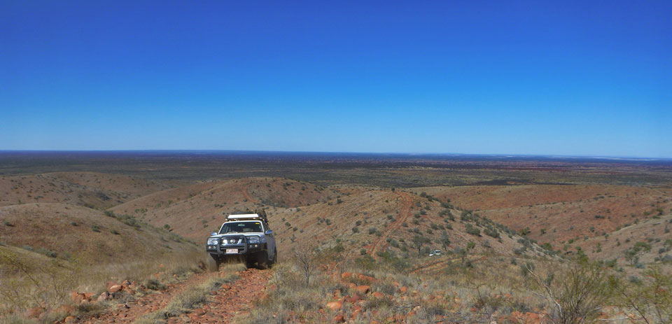
This Diamantina expedition travels into this remote and beautiful country, taking the path less travelled. It also offers the opportunity to connect with first contact Aboriginal people who walked out of the desert in 1984. We pick up at Uluru airport or Yulara resort (there is also an option to start with us from Alice Springs) and travel west into the Petermann Ranges. We take the Sandy Blight Junction Road north through the Gibson Desert to Kintore. We then travel west to Kiwirrkurra, Australia's most isolated Aboriginal community, and north to Lake MacKay. We follow an unmapped track deep into the Great Sandy Desert, eventually arriving at Balgo. We then travel through Tanami Downs Station on the old original Tanami Track before joining the Tanami Road to return to Alice Springs. This is a great expedition through country seldom seen by anyone - it's always better along the path less travelled.
This is a trip for those who really want to get away from it all. After the stunning beauty of the majestic Petermann Ranges, the Sandy Blight Junction road winds its way through beautiful stands of stately desert oaks. Further west we visit Australia’s most isolated Aboriginal community, then head north to Lake Mackay, the largest salt lake in the Western Deserts. The track we take from here is so little travelled we have never encountered another vehicle on it. The country is diverse, travelling across sandhills, desert ranges and claypans before finally culminating at the spectacular Balgo Pound. Turning south we travel along the little travelled original Tanami Track to Rabbit Flat where we join the Tanami Road to return to Alice Springs.
Day 1: We pick up at Ayers Rock airport and Yulara resort early afternoon(there is also the option of us picking you up in Alice Springs earlier in the day)and head west past Kata Tjuta to the spectacular Peterman Ranges. Crossing the Docker River and the Western Australian border we camp at the Rebecca Creek beneath statuesque ghost gums.
Day 2: After breakfast we travel to Warakurna where we visit Giles Meteorological Station and refuel before heading north along the Sandy Blight Junction Road to our camp beneath the Walter James Range. There is plenty of time to walk the spectacular gorge and explore Bungabiddy Rockhole
Day 3: We continue north along the Sandy Blight Junction Road through desert oak country. We drive through the fossil bed of Lake Hopkins. There is spectacular scenery and challenging steep driving as we ascend to the summit of the Frederick Range. This is one of the most spectacular views in Central Australia, with the Peterman Range to the south and the Kintore Range to the north, the entire distance of the Sandy Blight Junction Road laid out before us.
Day 4: The track cuts through dune fields. We wind our way back over the Northern Territory border and passes through the Davenport Hills. We lunch beneath the towering bluff of Mt Liesler, beside the remains of a tree blazed by the explorer William Tietkins. We travel through Kintore and take the Gary Junction road to our camp in the Dovers Hills.
Day 5: We visit Kiwirrkurra, Australia’s most remote Aboriginal community. We will visit the Women’s Centre and the modern Art Centre which is managed by Papunya Tula Artists. At Kiwirrkurra we meet our indigenous guides, and together with a facilitator we will head onto country. We will spend the day with these "first contacters", who were born and raised in the desert. They will demonstrate survival in this country. In the evening we will share a meal and listen to traditional stories or Tjukurpa (dreaming).
Day 6:
The following morning after a leisurely start we will say goodbye to the Pintubi and travel north through their traditional country to Lake MacKay, the second largest salt lake in Australia which straddles the border of the Northern Territory and Western Australia. Shortly beyond the lake we enter the sandhills of the Great Sandy Desert and our camp.
Day 7: A full day travelling north. We stop for water at Dwarf Well, there is the opportunity for a wash here. Further north there is a great diversity of country. We cross breakaways and claypans, and camp on a mulga flat beneath the Waterlander Breakaway.
Day 8: We travel on through Pintubi country. The country is constantly changing. We travel through Bilbarrd Aboriginal outstation, and cross Lake Claypan. As we head north the vegetation is slowly changeing. We pass Mangkala outstation, and visit an extraordinary Aboriginal stone quarry just south of Lamanbundah. Just north of here the country opens up to breakaways there there is digging of another kind. We are at the remains of the Point Moody Well, where in 1965 Aquitaine Petroleum drilled to a depth of 2441m. Nothing was found other than small gas shows, and the project was abandoned. We camp just south of the Stretch Range
Day 9: The country is becoming hilly. We come to a range full of indents and caves which was central to the Wati Kutjarra story of two young lizard men central to the dreaming of the Western Deserts. The holes in the rock signify where they were digging for snakes. We arive shortly in the sad abandoned town of Yagga Yagga. Social decay and a tragic suicide all contributed to the closure of this community in 2003. The people simply left, and all that remains is the infrastructure. It is a ghost town. Shortly afterwards we travel into sand hills again, we camp short of the Balgo Pound.
Day 10: We travel alongside the Balgo Pound with its spectacular breakaways and expansive vistas, eventually coming to Balgo, where we visit the famous art centre of the Warlayirti Artists. After lunch we follow the Kerney Range south east, along what ws once the original Tanami Track. Once we have passed through McGuire gap the country opens up into vast rolling downs. We are in the Tanami Desert. We camp just short of the Northern Territory Border on a claypan beneath Snappy Gums.
Day 11: We cross into the Northern Territory. We are now on Tanami Downs Station. It was originally called Mongrel Downs, but was renamed when it was transferred to indigenous ownership in the 1990s. It is still a working cattle station and we drive from bore to bore, opening and closing gates until we finally come to the homestead. From here it is only a half hour drive up to Rabbit Flat, where we join the Tanami Track for our run down past the Granites Gold Mine to our camp at Mt Doreen.
Day 12: We continue south to Tilmouth Well Roadhouse. The Western MacDonnell Ranges are to the south as we cross Burts Flat to arrive in Alice Springs mid afternoon, and the end of an extraordinary adventure across some ot the last unmapped tracks in Australia.
Recently viewed